The Grande Ronde River’s Volcanic History
As you drift down the stunning, sun-drenched canyons of the Grande Ronde River, it’s impossible to ignore the dramatic landscape that surrounds you. The towering cliffs, stacked in immense, dark layers like a giant stone cake, tell a story of unimaginable geological violence and continental construction. This isn't just any river canyon; it's a living, open-air museum, a place where you can witness hundreds of millions of years of Earth's history from the comfort of your raft. With Winding Waters River Expeditions, your Grande Ronde River rafting trip is transformed into a journey through deep time. This guide will help you learn how to read the rocks like a pro and understand the colossal forces that shaped this unique and beautiful corner of the world.
Many of our guests at
Winding Waters River Expeditions ask us about the incredible rock formations. This comprehensive guide is our answer—a deep dive into the volcanic heart of the Grande Ronde, designed to make your next river adventure even more meaningful.
The Deep Foundation: Exotic Islands from a Lost Ocean
Long before the first volcanoes erupted, the story of the Grande Ronde began in a lost ocean, hundreds of millions of years ago. The oldest rocks you'll find in this region are not native to North America. They are what geologists call
"exotic terranes"—fragments of ancient volcanic islands and seafloor that formed near the present-day Aleutian Islands around 300 million years ago [1]. These islands, through the slow, inexorable march of tectonic plates, "rafted" across the ancient Pacific and collided with the western edge of the North American continent. This collision, a process that took millions of years, literally plastered new land onto the continent, forming the very first part of what would become Oregon. When you hike the hillsides on your
multi-day Grande Ronde expedition, you are walking on land that has traveled thousands of miles across an ocean to be here.
The Main Event: The Columbia River Flood Basalts
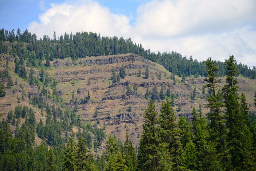
The most dominant and dramatic features of the Grande Ronde canyon are the immense layers of dark volcanic rock. These are part of the Columbia River Basalt Group (CRBG), the youngest, smallest, and one of the best-preserved continental flood basalt provinces on Earth [2]. Between 17 and 16 million years ago, this region was torn apart by immense fissures in the Earth's crust. Instead of forming a classic cone-shaped volcano, these fissures, known as the Chief Joseph Dike Swarm, unleashed an unimaginable volume of fluid basaltic lava that flooded the landscape.
The Grande Ronde Basalt, which makes up the bulk of the canyon walls, accounts for over 70% of the entire Columbia River Basalt Group's volume, erupting in an astonishingly short period of just 400,000 years [3].
These weren't gentle flows; they were catastrophic events. Lava surged across 210,000 square kilometers of present-day Oregon, Washington, and Idaho, filling valleys and creating a vast, flat lava plain. The Grande Ronde River has since carved its way down through these layers, exposing them for us to see. The sheer scale of this event is hard to comprehend. The volume of the Grande Ronde Basalt alone is estimated to be around 150,400 cubic kilometers [4]. To put that in perspective, that's enough lava to cover the entire state of Texas in a layer over 200 meters (650 feet) thick.
How to Read the Basalt Layers: A Rafter's Field Guide
As you float the river with
Winding Waters River Expeditions, you can distinguish between different parts of the lava flows. Here’s a quick field guide to help you identify what you’re seeing:
| Feature | Description | How to Spot It |
|---|---|---|
| Flow Tops | The upper part of a lava flow, often characterized by vesicles (gas bubbles) and a rubbly appearance. This section cooled quickly, trapping gases. | Look for porous, reddish-brown rock at the top of a distinct horizontal layer. The red color comes from the oxidation (rusting) of iron-rich minerals. |
| Flow Interiors | The thick, central part of the flow that cooled slowly, forming dense, hard basalt. This is the structural backbone of the cliffs. | These are the massive, dark grey to black sections of the cliffs. They are much more solid and uniform than the flow tops. |
| Columnar Basalt | As the lava cooled and contracted, it often fractured into geometric columns, typically hexagonal. This is one of the most iconic features of basalt flows worldwide. | Look for vertical columns, resembling giant organ pipes, especially at the base of thick flows. They are a stunning display of the physics of cooling lava. |
| Feeder Dikes | The vertical conduits through which the lava reached the surface. These are the ancient plumbing of the volcanic system. | These appear as vertical bands of rock that cut across the horizontal flow layers. They are often more resistant to erosion and stand out as fins or walls. |
Spotting a
feeder dike is like finding the ancient plumbing of the volcanic system. The Chief Joseph Dike Swarm consists of thousands of these dikes, each one a pathway for molten rock from deep within the Earth. Civil engineers even used these incredibly strong feeder dikes as foundations for bridge abutments in the region [5]. When you see one, you're looking at the very channel that fed these colossal lava flows. It's a direct connection to the fiery heart of the Earth, right here on your
Winding Waters
Grande Ronde rafting adventure.
A Landscape Shaped by Water and Time
The story doesn't end with the lava. For the last 15 million years, the forces of erosion have been at work. The Grande Ronde River, along with cataclysmic ice-age floods, has relentlessly carved through the thick basalt layers, creating the deep, dramatic canyon we see today. The river's path exposes not just the basalt, but also lighter-colored layers of sandstone and clay that were deposited in the periods between lava flows, giving the canyon walls their distinctly layered appearance.
Your
Grande Ronde River adventure with Winding Waters is more than just a vacation; it's a hands-on geology lesson. From the ancient island fragments beneath your feet to the colossal lava flows towering above, you are surrounded by the raw power of our planet's history. So as you relax on the raft, take a moment to read the rocks. Each layer, each column, and each dike tells a part of this incredible story.
Frequently Asked Questions about Grande Ronde Geology
How thick are the basalt layers?
Individual flows can be tens of meters thick, and the total stack of basalt in the canyon can be over a kilometer (more than half a mile) thick in some places.
Are the volcanoes still active?
No, the Columbia River Basalt volcanism ended millions of years ago. The region is now geologically stable.
Can I find any fossils in the rocks?
While the basalt itself is volcanic and doesn't contain fossils, the sedimentary layers (sandstone and clay) between the flows can sometimes contain fossilized plant material, like leaf imprints or petrified wood.
What makes the columns hexagonal?
As the lava cools and contracts, it fractures. The most efficient way for a surface to crack to relieve tension is in a hexagonal pattern, which is why you see this shape in nature in places like honeycombs and, in this case, cooling basalt.
Ready to see it for yourself? The best way to experience the geology of the Grande Ronde is on the river. Book your
3-Day or
5-Day Grande Ronde River trip with
Winding Waters River Expeditions today and experience a journey through deep time. Our knowledgeable guides are passionate about the river and its history, and they love to share their insights with our guests. We at
Winding Waters River Expeditions believe that understanding the story of the landscape makes the adventure of rafting the
Grande Ronde River that much more special.